
Map Room
RUSSIA & UKRAINE
MIDDLE EAST
CHINA & TAIWAN

ADVERSARIES
INFORMATION OPERATIONS
THE FUTURE OF WAR PROJECT
Search
Date
Team
Focus Area
Map Series
Product Line
Map Type
Static Map
Dec 14, 2025

RUSSIA & UKRAINE
UKRAINE
Assessed Control of Terrain in the Kherson Direction, December 14, 2025 at 1:30 PM ET
Static Map
Dec 14, 2025

RUSSIA & UKRAINE
UKRAINE
Assessed Control of Terrain in Zaporizhia Oblast, December 14, 2025 at 1:30 PM ET
Static Map
Dec 14, 2025
RUSSIA & UKRAINE
UKRAINE
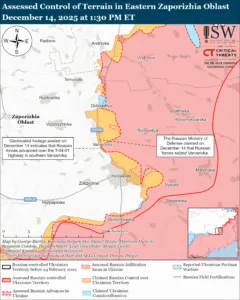
Assessed Control of Terrain in Eastern Zaporizhia Oblast, December 14, 2025 at 1:30 PM ET
Static Map
Dec 14, 2025

RUSSIA & UKRAINE
UKRAINE
Assessed Control of Terrain in the Pokrovsk Direction, December 14, 2025 at 1:30 PM ET
Static Map
Dec 14, 2025

RUSSIA & UKRAINE
UKRAINE
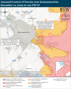
Assessed Control of Terrain near Kostyantynivka, December 14, 2025 at 1:30 PM ET
Static Map
Dec 14, 2025

RUSSIA & UKRAINE
UKRAINE
Assessed Control of Terrain in Donetsk Oblast, December 14, 2025 at 1:30 PM ET
Static Map
Dec 14, 2025

RUSSIA & UKRAINE
UKRAINE
Assessed Control of Terrain in Luhansk Oblast, December 14, 2025 at 1:30 PM ET
Static Map
Dec 14, 2025

RUSSIA & UKRAINE
UKRAINE
Assessed Control of Terrain in the Kharkiv Direction, December 14, 2025 at 1:30 PM ET
Static Map
Dec 14, 2025

RUSSIA & UKRAINE
UKRAINE
Assessed Control of Terrain in the Sumy Direction, December 14, 2025 at 1:30 PM ET
Static Map
Dec 14, 2025

RUSSIA & UKRAINE
UKRAINE
Assessed Control of Terrain in the Russo-Ukrainian War, December 14, 2025 at 1:30 PM ET
Static Map
Dec 13, 2025

RUSSIA & UKRAINE
UKRAINE
Assessed Control of Terrain in the Kherson Direction, December 13, 2025 at 1:30 PM ET
Static Map
Dec 13, 2025
RUSSIA & UKRAINE
UKRAINE
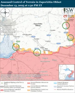
Assessed Control of Terrain in Zaporizhia Oblast, December 13, 2025 at 1:30 PM ET
Static Map
Dec 13, 2025
RUSSIA & UKRAINE
UKRAINE
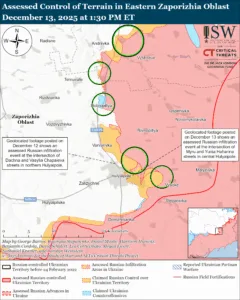
Assessed Control of Terrain in Eastern Zaporizhia Oblast, December 13, 2025 at 1:30 PM ET
Static Map
Dec 13, 2025
RUSSIA & UKRAINE
UKRAINE
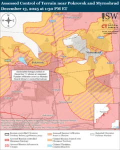
Assessed Control of Terrain in Pokrovsk and Myrnohrad, December 13, 2025 at 1:30 PM ET
Static Map
Dec 13, 2025
Static Map
Dec 13, 2025
RUSSIA & UKRAINE
UKRAINE
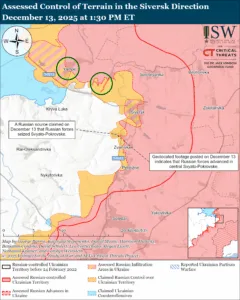
Assessed Control of Terrain in the Siversk Direction, December 13, 2025 at 1:30 PM ET
Static Map
Dec 13, 2025
RUSSIA & UKRAINE
UKRAINE
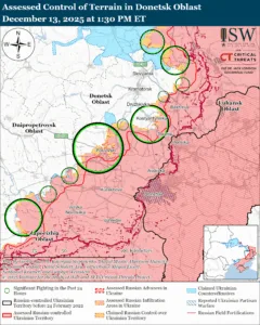
Assessed Control of Terrain in the Donetsk Oblast, December 13, 2025 at 1:30 PM ET
Static Map
Dec 13, 2025
RUSSIA & UKRAINE
UKRAINE
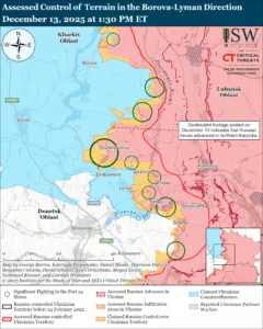
Assessed Control of Terrain in the Borova-Lyman Direction, December 13, 2025 at 1:30 PM ET
Static Map
Dec 13, 2025
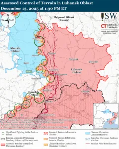
RUSSIA & UKRAINE
UKRAINE
Assessed Control of Terrain in the Luhansk Oblast, December 13, 2025 at 1:30 PM ET
Static Map
Dec 13, 2025
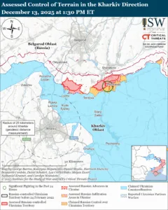
RUSSIA & UKRAINE
UKRAINE
Assessed Control of Terrain in the Kharkiv Direction, December 13, 2025 at 1:30 PM ET
Static Map
Dec 13, 2025
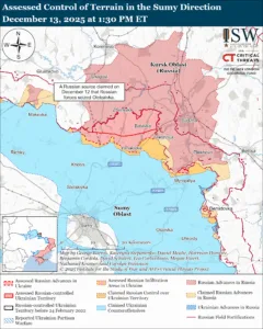
RUSSIA & UKRAINE
UKRAINE
Assessed Control of Terrain in the Sumy Direction, December 13, 2025 at 1:30 PM ET
Static Map
Dec 13, 2025
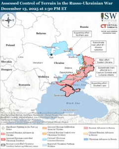
RUSSIA & UKRAINE
UKRAINE
Assessed Control of Terrain in the Russo-Ukrainian War, December 13, 2025 at 1:30 PM ET
Static Map
Dec 13, 2025
RUSSIA & UKRAINE
UKRAINE
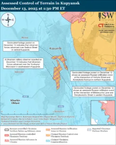
Assessed Control of Terrain in Kupyansk, December 13, 2025 at 1:30 PM ET
Static Map
Dec 13, 2025
RUSSIA & UKRAINE
UKRAINE
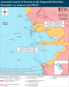
Assessed Control of Terrain in the Kupyansk Direction, December 13, 2025 at 1:30 PM ET
Static Map
Dec 13, 2025
RUSSIA & UKRAINE
UKRAINE
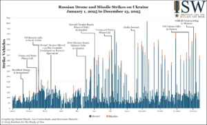
Russian Drone and Missile Strikes on Ukraine, January 1, 2025 to December 13, 2025
Static Map
Dec 12, 2025
RUSSIA & UKRAINE
UKRAINE
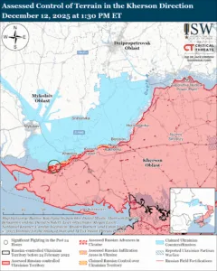
Assessed Control of Terrain in the Kherson Direction, December 12, 2025 at 1:30 PM ET
Static Map
Dec 12, 2025
RUSSIA & UKRAINE
UKRAINE
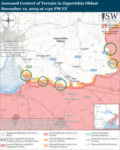
Assessed Control of Terrain in Zaporizhia Oblast, December 12, 2025 at 1:30 PM ET
Static Map
Dec 12, 2025
RUSSIA & UKRAINE
UKRAINE
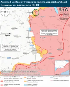
Assessed Control of Terrain in Eastern Zaporizhia Oblast, December 12, 2025
Static Map
Dec 12, 2025
RUSSIA & UKRAINE
UKRAINE
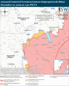
Assessed Control of Terrain in the Eastern Dnipropetrovsk Direction, December 12, 2025
Static Map
Dec 12, 2025
RUSSIA & UKRAINE
UKRAINE